
Dolga njiva mountain
Mountains: Kamnik - Savinja Alps
Latitude/longitude: 46,3103°N / 14,5414°E
Altitude: 1688 m
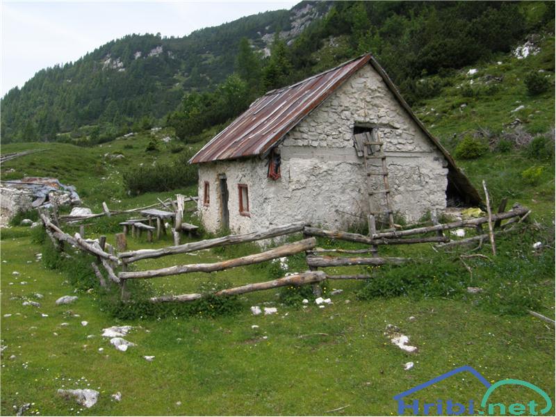
Description: Dolga Njiva mountain is located in broad pasture areas under Veliki Zvoh and Koren peak. The mountain has two smaller cottages on it and is full of livestock in the summertime (mainly horses and sheep, which often leave the mountain and graze on the slopes of Kalški greben).
Paths:
Dom na Gospincu - Dolga Njiva mountain (Krvavec)
Mountains: Kamnik - Savinja Alps
Latitude/longitude: 46,2957°N / 14,5214°E
Altitude: 1688m
Starting point: Dom na Gospincu (1491 m)
Altitude difference: 197 m
Walking time: 1 h 35 min
Difficulty: easy marked path
Best season for the hike: summer season
Recommended: mountain hiking footwear, hiking poles, crampons and pick in the winter
Access to starting point:
1. From the highway Ljubljana - Jesenice, take the exit Vodice then continue to the first crossroads with a traffic light in Vodice, turning left towards Cerklje na Gorenjskem and Brnik. When you reach the main roundabout in Spodnji Brnik, continue driving towards Cerklje and the Krvavec ski resort. At the end of the town of Cerklje na Gorenjskem, leave the main road which continues towards Velesovo and Visoko and continue slightly to the right towards Krvavec ski resort. We park at the large, orderly parking lot next to the bottom station of the Krvavec cable car, purchase a ticket and take the cable car to the top station which is next to the Dom na Gospincu mountain lodge.
2. From the highway Jesenice - Ljubljana take the exit Kranj - vzhod then continue to drive towards Brnik, Komenda and Mengeš. When you reach the main roundabout in Spodnji Brnik, continue driving towards Cerklje and the Krvavec ski resort. At the end of the town of Cerklje na Gorenjskem, leave the main road which continues towards Velesovo and Visoko and continue slightly to the right towards Krvavec ski resort. We park at the large, orderly parking lot next to the bottom station of the Krvavec cable car, purchase a ticket and take the cable car to the top station which is next to the Dom na Gospincu mountain lodge.
3. From the highway Ljubljana - Jesenice, take the exit Vodice then continue to the first crossroads with a traffic light in Vodice, turning left towards Cerklje na Gorenjskem and Brnik. When you reach the main roundabout in Spodnji Brnik, continue driving towards Cerklje and the Krvavec ski resort. At the end of the town of Cerklje na Gorenjskem, leave the main road which continues towards Velesovo and Visoko and continue slightly to the right towards Krvavec ski resort. Continue to the village Grad, where markings for the settlement Ambrož pod Krvavcem will direct you to the right, onto a steep asphalt road (going straight brings you to the lower station of the cable car Krvavec and Štefanja Gora). When the incline on the steep road evens out a bit, you reach the crossroads, where you continue left towards the settlement Ambrož pod Krvavcem (straight settlements Ravne, Apno and Šentruška Gora). A bit further on, the road transitionally turns into a slight descent, then climbs over slopes that occasionally offer quite a good view. Higher, we reach Ambrož pd Krvavcem, where we drive around the church of St. Ambrož and tourist farm Pr Ambružarju on the left side. From the farm, the road passes into a forest, then climbs all the way to the Jezerca peak, where you will find a large, orderly parking lot. The road gets flatter here and turns left, then, about 500 m on, it takes us to a crossroads where we turn slightly to the left towards the top station of the cable car and the mountain lodge on Gospinec (Kriška Planina to the right). We follow the gravel road for a while longer until we reach the top station of the cable car.
Recently, the road from the Jezerca peak to Dom na Gospincu had been closed, which extends the hike for approximately 30 minutes.
4. From the highway Jesenice - Ljubljana take the exit Kranj - vzhod then continue to drive towards Brnik, Komenda and Mengeš. When you reach the main roundabout in Spodnji Brnik, continue driving towards Cerklje and the Krvavec ski resort. At the end of the town of Cerklje na Gorenjskem, leave the main road which continues towards Velesovo and Visoko and continue slightly to the right towards Krvavec ski resort. Continue to the village Grad, where markings for the settlement Ambrož pod Krvavcem will direct you to the right, onto a steep asphalt road (going straight brings you to the lower station of the cable car Krvavec and Štefanja Gora). When the incline on the steep road evens out a bit, you reach the crossroads, where you continue left towards the settlement Ambrož pod Krvavcem (straight settlements Ravne, Apno and Šentruška Gora). A bit further on, the road transitionally turns into a slight descent, then climbs over slopes that occasionally offer quite a good view. Higher, we reach Ambrož pd Krvavcem, where we drive around the church of St. Ambrož and tourist farm Pr Ambružarju on the left side. From the farm, the road passes into a forest, then climbs all the way to the Jezerca peak, where you will find a large, orderly parking lot. The road gets flatter here and turns left, then, about 500 m on, it takes us to a crossroads where we turn slightly to the left towards the top station of the cable car and the mountain lodge on Gospinec (Kriška Planina to the right). We follow the gravel road for a while longer until we reach the top station of the cable car.
Recently, the road from the Jezerca peak to Dom na Gospincu had been closed, which extends the hike for approximately 30 minutes.
Path description: At the upper station of the cable car to Krvavec, we notice numerous mountaineering direction signs. We head towards the lodge Dom na Krvavcu and Marija Snežna, along a poorly visible path, which climbs along the grassy slope almost straight upwards. The poorly visible path leads us higher through the grazing fence, beyond which it becomes somewhat easier to follow. The reasonably steep path then brings us to the Dom na Krvavcu lodge, which we could already see from the upper ski lift station (we can reach it along a gravel road of lesser quality as well). We continue towards Zvoh along the road, which takes us past the chapel and transmitters at Krvavec and to the Razor saddle (saddle between Krvavec and Veliki Zvoh), where there is a crossroad.
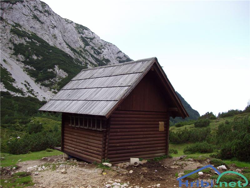
We continue straight along the ridge (left, peak of Krvavec, 5 minutes) to the next crossroad, where the signs for Dolga Njiva direct us to the left (straight Veliki Zvoh). The path to Dolga Njiva then crosses a skiing slope and brings us to a slope, partly overgrown with brush. A diagonal path leaves the area of Krvavec skiing slopes after a while, crossing a wire fence. First, it descends through the brush, then diagonally through some smaller and partly overgrown screes. The path then ceases to descend and a path from Kokra joins us from the left (across Lojtra). A few more steps bring us to the old pasture cottage at the Dolga Njiva mountain.
The hike can be extended to the following destinations: Koren peak (50 min), Kalška gora (2 h 20 min), Kalški greben (1 h 45 min)
Kokra (Podlebelca) - Dolga Njiva mountain (Krvavec)
Mountains: Kamnik - Savinja Alps
Latitude/longitude: 46,3147°N / 14,5117°E
Altitude: 1688 m
Starting point: Kokra (Podlebelca) (850 m)
Altitude difference: 838 m
Walking time: 2 h 45 min
Difficulty: moderately demanding marked path
Best season for the hike: summer season
Recommended: helmet, mountain hiking footwear, hiking poles, crampons and pick in the winter
Access to starting point: From the highway Ljubljana - Jesenice we take the exit Kranj - vzhod and follow the road towards Zgornje Jezersko. In the village Kokra, at the road markings between 10,5 and 10 km, a road splits to the right towards Spodnja Kokra (mountain markings by the crossroad as well). We continue along the narrow asphalt road, which runs between a church on the right and the river Kokra on the left. The road begins to ascend and in the crossroad, we follow it in the direction of the Roblek farm. We park at a medium sized parking lot, where a marked path crosses the road by which we are parking (the footpath is poorly marked).
Path description: At the end of the parking lot, we notice a poorly marked dirt track, which crosses the road. Here, we take a right onto the dirt track which ascends moderately through a forest. We follow it to a crossroad where an unmarked path from the Roblek farm joins from the right. We continue straight forward, first along the broad dirt track, but we leave it soon, as the markings direct us right to a footpath. Further on, a not too steep path takes us to a larger rock, where there is next marked crossroad. We continue straight forward (Krvavec to the right) along the path, which gradually begins to climb steeper and, higher, brings us under an extensive rockfall, which could already be seen from the Kokra river valley. The path evades the rockfall somewhat to the left, then, once we reach higher ground, turns right and comes entirely close to the rocky peaks on our right. The path then takes us into a short belt of brush at a moderate incline, after which we reach Lojtra. Lojtra is a slightly exposed passage along a wide and well protected shelf. Once we complete this path, a short crossing of slopes follows (Jeklenica), before the steepness grows milder. We continue along the path which ascends through brush. After 15 minutes, the brush ends and we reach the broad pastures of Dolga Njiva mountain, where we see a crossroad. We continue straight (Krvavec to the right) and after a few steps see the old pasture cottage on the mountain.
The hike can be extended to the following destinations: Koren peak, Kalška gora, Kalški greben
Planina Jezerca - Dolga Njiva mountain (Krvavec) (past Dom na Krvavcu mountain lodge)
Mountains: Kamnik - Savinja Alps
Latitude/longitude: 46,2855°N / 14,5314°E
Altitude: 1688 m
Starting point: Planina Jezerca (1410 m)
Altitude difference: 278 m
Walking time: 1 h 50 min
Difficulty: easy marked path
Best season for the hike: summer season
Recommended: mountain hiking footwear, hiking poles, crampons and pick in the winter
Access to starting point:
1. From the highway Ljubljana - Jesenice, take the exit Vodice then continue to the first crossroads with a traffic light in Vodice, turning left towards Cerklje na Gorenjskem and Brnik. When you reach the main roundabout in Spodnji Brnik, continue driving towards Cerklje and the Krvavec ski resort. At the end of the town of Cerklje na Gorenjskem, leave the main road which continues towards Velesovo and Visoko and continue slightly to the right towards Krvavec ski resort. Continue to the village Grad, where markings for the settlement Ambrož pod Krvavcem will direct you to the right, onto a steep asphalt road (going straight brings you to the lower station of the cable car Krvavec and Štefanja Gora). When the incline on the steep road evens out a bit, you reach the crossroads, where you continue left towards the settlement Ambrož pod Krvavcem (straight settlements Ravne, Apno and Šentruška Gora). A bit further on, the road transitionally turns into a slight descent, then climbs over slopes that occasionally offer quite a good view. Higher, we reach Ambrož pd Krvavcem, where we drive around the church of St. Ambrož and tourist farm Pr Ambružarju on the left side. From the farm, the road passes into a forest, then climbs all the way to the Jezerca peak, where you will find a large, orderly parking lot.
2. From the highway Jesenice - Ljubljana take the exit Kranj - vzhod then continue to drive towards Brnik, Komenda and Mengeš. When you reach the main roundabout in Spodnji Brnik, continue driving towards Cerklje and the Krvavec ski resort. At the end of the town of Cerklje na Gorenjskem, leave the main road which continues towards Velesovo and Visoko and continue slightly to the right towards Krvavec ski resort. Continue to the village Grad, where markings for the settlement Ambrož pod Krvavcem will direct you to the right, onto a steep asphalt road (going straight brings you to the lower station of the cable car Krvavec and Štefanja Gora). When the incline on the steep road evens out a bit, you reach the crossroads, where you continue left towards the settlement Ambrož pod Krvavcem (straight settlements Ravne, Apno and Šentruška Gora). A bit further on, the road transitionally turns into a slight descent, then climbs over slopes that occasionally offer quite a good view. Higher, we reach Ambrož pd Krvavcem, where we drive around the church of St. Ambrož and tourist farm Pr Ambružarju on the left side. From the farm, the road passes into a forest, then climbs all the way to the Jezerca peak, where you will find a large, orderly parking lot.
Path description: At the end of the parking lot, where the road turns left and the road towards the nearby Jezerca peak leads right, we notice red mountain direction signs, which direct us straight onto the marked footpath towards Kriška peak, Koren peak, Košutna, Kompotel and Mokrica, which climbs through the pastures of the already mentioned peak. After a shorter ascent, we reach the dirt track and follow it left, where we cross the peak Kržišča (1658 m). The dirt track which we are walking on quickly divides into two parts, we continue on the lower one. Transitionally, we see a lovely view of Kranj, Škofja Loka hills and Storžič, then the path begins to descend slightly. A few minutes of walk follow until we reach the parking lot in the lower part of Kriška mountain.
Here, the marked path towards the Koren peak continues slightly to the right while we proceed straight forward onto the other side of the valley, where we begin to climb the grassy slope towards the nearby settlement. After a shorter ascent, we reach the pasture hut Pr Florjan, which we pass along the right side. Above the pasture hut, we gradually begin to walk along a well trodden but poorly marked path, which climbs steeper along the grassy slope. Higher, we reach a poorer, partly grassy dirt track and continue to the place where it turns right. From this curve, we take a slightly less visible path, which, in a few minutes, takes us to the Dom na Krvavcu mountain lodge.
At Dom na Krvavcu mountain lodge, we step onto a gravel road and begin to climb it in the direction of Krvavec and Zvoh peaks. As we keep ascending, we get a beautiful view of the Storžič mountain group, Kočna and Grintovec, while the path takes us past the transmitter tower and gradually onto somewhat steeper slopes of the Krvavec peak. Here, the road growls flatter again and crosses the western slopes of the mentioned peak, then soon brings us to the Razor saddle.
At the saddle, unnoticeably, a path from the Koren mountain joins our path (the path splits off from the marked path Kriška mountain - Koren mountain a bit before Koren mountain), while we continue straight forward to the nearby red direction signs, which are placed a bit before a crossroad, where a marked path towards the Dolga Njiva mountain splits off a bit to the left.
We continue left in the direction of Dolga Njiva (straight for Veliki Zvoh) and first walk along a worse road (later dirt track and mountain path) which crosses a skiing track, descending from the top of Zvoh. Further on, the path brings us to the slope, which is partly overgrown in brush and a wire fence, which marks and protects the end of the Krvavec skiing slopes.
We cross the fence and the path, with lovely sights, brings us onto north - northwest slopes, which we descend along through a belt of brush. The path first diagonally descends across a few smaller and partly overgrown screes, then gradually grows flatter. A path from Kokra (across Lojtra) joins us from the left. We continue straight on and quickly arrive to the old pasture cottage on the Dolga Njiva mountain, and a newer one a bit higher.
When the skiing resort is operational, walking along the part of the path which crosses the skiing tracks is forbidden.
The hike can be extended to the following destinations: Koren peak, Kalška gora, Kalški greben
