
Krvavec
Mountains: Kamnik - Savinja Alps
Latitude/longitude: 46,29964°N / 14,53663°E
Altitude: 1853 m
Description: Krvavec is a 1853 m high peak in the centre of a ski resort with the same name. From the peak, laced in ski lifts, we have a beautiful view of Gorenjska region and a part of Kamnik - Savinja Alps.
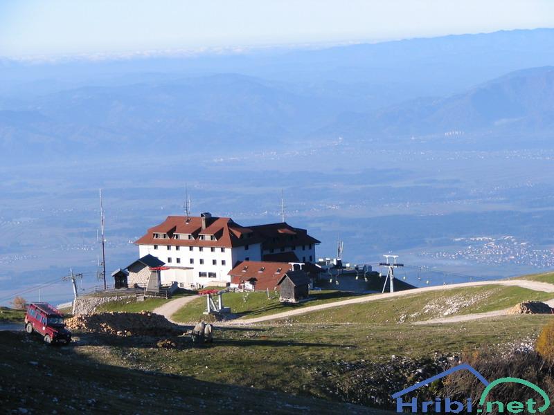
Dom na Krvavcu
Paths:
Dom na Gospincu - Krvavec
Mountains: Kamnik - Savinja Alps
Latitude/longitude: 46,2957°N / 14,5214°E
Altitude: 1853 m
Starting point: Dom na Gospincu (1492 m)
Altitude difference: 361 m
Walking time: 1 h
Difficulty: easy unmarked trail
Best season for the hike: summer season
Recommended: mountain hiking footwear, hiking poles, crampons in the winter
Access to starting point:
1. From the highway Ljubljana - Jesenice, take the exit Vodice then continue to the first crossroads with a traffic light in Vodice, turning left towards Cerklje na Gorenjskem and Brnik. When you reach the main roundabout in Spodnji Brnik, continue driving towards Cerklje and the Krvavec ski resort. At the end of the town of Cerklje na Gorenjskem, leave the main road which continues towards Velesovo and Visoko and continue slightly to the right towards Krvavec ski resort. Park on the large and orderly parking lot by the lowest station of the cable car Krvavec, purchase the ski lift ticket and take the lift to the upper station, located next to the mountain lodge Dom na Gospincu.
2. From the highway Jesenice - Ljubljana take the exit Kranj - vzhod then continue to drive towards Brnik, Komenda and Mengeš. When you reach the main roundabout in Spodnji Brnik, continue driving towards Cerklje and the Krvavec ski resort. At the end of the town of Cerklje na Gorenjskem, leave the main road which continues towards Velesovo and Visoko and continue slightly to the right towards Krvavec ski resort. Park on the large and orderly parking lot by the lowest station of the cable car Krvavec, purchase the ski lift ticket and take the lift to the upper station, located next to the mountain lodge Dom na Gospincu.
3. From the highway Ljubljana - Jesenice, take the exit Vodice then continue to the first crossroads with a traffic light in Vodice, turning left towards Cerklje na Gorenjskem and Brnik. When you reach the main roundabout in Spodnji Brnik, continue driving towards Cerklje and the Krvavec ski resort. At the end of the town of Cerklje na Gorenjskem, leave the main road which continues towards Velesovo and Visoko and continue slightly to the right towards Krvavec ski resort. Continue to the village Grad, where markings for the settlement Ambrož pod Krvavcem will direct you to the right, onto a steep asphalt road (going straight brings you to the lower station of the cable car Krvavec and Štefanja Gora). When the incline on the steep road evens out a bit, you reach the crossroads, where you continue left towards the settlement Ambrož pod Krvavcem (straight settlements Ravne, Apno and Šentruška Gora). A bit further on, the road transitionally turns into a slight descent, then climbs over slopes that occasionally offer quite a good view. Higher, we reach Ambrož pd Krvavcem, where we drive around the church of St. Ambrož and tourist farm Pr Ambružarju on the left side. From the farm, the road passes into a forest, then climbs all the way to the Jezerca peak, where you will find a large, orderly parking lot. The road flattens here and turns left. Some 500 meters on, it takes us to a crossroads, where we continue slightly to the left (right Kriška mountain). Along the gravel road, we then drive to the top station of the cable car.
Recently, the road from the Jezerca peak to the Dom na Gospincu mountain lodge has been closed for traffic, which extends the hike for approximately 30 minutes.
4. From the highway Jesenice - Ljubljana take the exit Kranj - vzhod then continue to drive towards Brnik, Komenda and Mengeš. When you reach the main roundabout in Spodnji Brnik, continue driving towards Cerklje and the Krvavec ski resort. At the end of the town of Cerklje na Gorenjskem, leave the main road which continues towards Velesovo and Visoko and continue slightly to the right towards Krvavec ski resort. Continue to the village Grad, where markings for the settlement Ambrož pod Krvavcem will direct you to the right, onto a steep asphalt road (going straight brings you to the lower station of the cable car Krvavec and Štefanja Gora). When the incline on the steep road evens out a bit, you reach the crossroads, where you continue left towards the settlement Ambrož pod Krvavcem (straight settlements Ravne, Apno and Šentruška Gora). A bit further on, the road transitionally turns into a slight descent, then climbs over slopes that occasionally offer quite a good view. Higher, we reach Ambrož pd Krvavcem, where we drive around the church of St. Ambrož and tourist farm Pr Ambružarju on the left side. From the farm, the road passes into a forest, then climbs all the way to the Jezerca peak, where you will find a large, orderly parking lot. The road flattens here and turns left. Some 500 meters on, it takes us to a crossroads, where we continue slightly to the left (right Kriška mountain). Along the gravel road, we then drive to the top station of the cable car.
Recently, the road from the Jezerca peak to the Dom na Gospincu mountain lodge has been closed for traffic, which extends the hike for approximately 30 minutes
Path description: At the upper station of the cable car to Krvavec, we notice numerous mountaineering direction signs. We head towards the lodge Dom na Krvavcu and Marija Snežna, along a poorly visible path, which climbs along the grassy slope almost straight upwards. The poorly visible path leads us higher through the grazing fence, beyond which it becomes somewhat easier to follow. The reasonably steep path then brings us to the Dom na Krvavcu lodge, which we could already see from the upper ski lift station (we can reach it along a gravel road of lesser quality as well).
From the lodge, we continue in the direction of Zvoh along a road, which leads us past a chapel and transmitters on Krvavec, to the Razor saddle (saddle between Krvavec peak and Veliki Zvoh), where there is a crossroad. We continue along the right road, which brings us to the top of Krvavec peak after 5 minutes of walking.
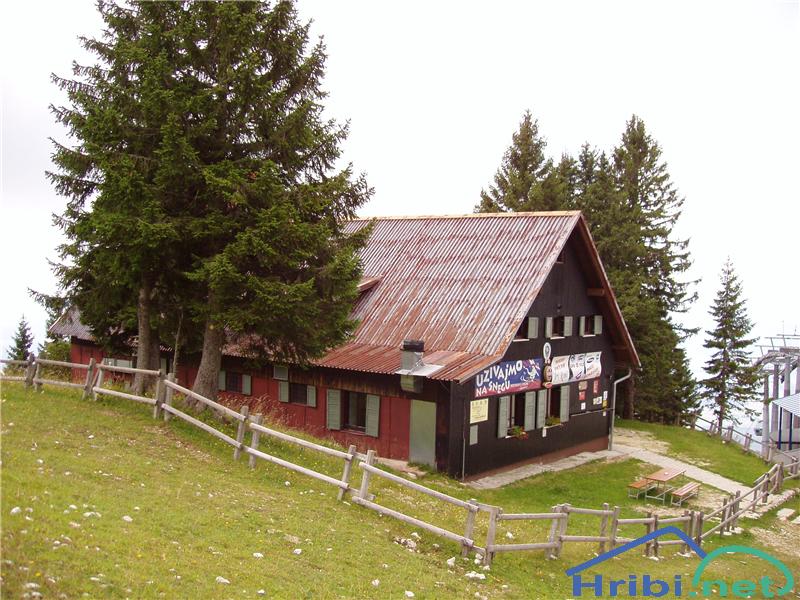
Dom na Gospincu
Jezerca Peak - Krvavec
Mountains: Kamnik - Savinja Alps
Latitude/longitude: 46,2855°N / 14,5314°E
Altitude: 1853 m
Starting point: Jezerca Peak (1410 m)
Altitude difference: 443 m
Walking time: 1 h 10 min
Difficulty: easy and marked path
Best season for the hike: summer season
Recommended: mountain hiking footwear, hiking poles, crampons and ice pick in the winter
Access to starting point:
1. From the highway Ljubljana - Jesenice, take the exit Vodice then continue to the first crossroads with a traffic light in Vodice, turning left towards Cerklje na Gorenjskem and Brnik. When you reach the main roundabout in Spodnji Brnik, continue driving towards Cerklje and the Krvavec ski resort. At the end of the town of Cerklje na Gorenjskem, leave the main road which continues towards Velesovo and Visoko and continue slightly to the right towards Krvavec ski resort. Continue to the village Grad, where markings for the settlement Ambrož pod Krvavcem will direct you to the right, onto a steep asphalt road (going straight brings you to the lower station of the cable car Krvavec and Štefanja Gora). When the incline on the steep road evens out a bit, you reach the crossroads, where you continue left towards the settlement Ambrož pod Krvavcem (straight settlements Ravne, Apno and Šentruška Gora). A bit further on, the road transitionally turns into a slight descent, then climbs over slopes that occasionally offer quite a good view. Higher, we reach Ambrož pd Krvavcem, where we drive around the church of St. Ambrož and tourist farm Pr Ambružarju on the left side. From the farm, the road passes into a forest, then climbs all the way to the Jezerca peak, where you will find a large, orderly parking lot.
2. From the highway Jesenice - Ljubljana take the exit Kranj - vzhod then continue to drive towards Brnik, Komenda and Mengeš. When you reach the main roundabout in Spodnji Brnik, continue driving towards Cerklje and the Krvavec ski resort. At the end of the town of Cerklje na Gorenjskem, leave the main road which continues towards Velesovo and Visoko and continue slightly to the right towards Krvavec ski resort. Continue to the village Grad, where markings for the settlement Ambrož pod Krvavcem will direct you to the right, onto a steep asphalt road (going straight brings you to the lower station of the cable car Krvavec and Štefanja Gora). When the incline on the steep road evens out a bit, you reach the crossroads, where you continue left towards the settlement Ambrož pod Krvavcem (straight settlements Ravne, Apno and Šentruška Gora). A bit further on, the road transitionally turns into a slight descent, then climbs over slopes that occasionally offer quite a good view. Higher, we reach Ambrož pd Krvavcem, where we drive around the church of St. Ambrož and tourist farm Pr Ambružarju on the left side. From the farm, the road passes into a forest, then climbs all the way to the Jezerca peak, where you will find a large, orderly parking lot.
Path description: At the end of the parking lot, where the road turns left and the road towards the nearby Jezerca peak leads right, we notice red mountain direction signs, which direct us straight onto the marked footpath towards Kriška peak, Koren peak, Košutna, Kompotel and Mokrica, which climbs through the pastures of the already mentioned peak. After a shorter ascent, we reach the dirt track and follow it left, where we cross the peak Kržišča (1658 m). The dirt track which we are walking on quickly divides into two parts, we continue on the lower one. Transitionally, we see a lovely view of Kranj, Škofja Loka hills and Storžič, then the path begins to descend slightly. A few minutes of walk follow until we reach the parking lot in the lower part of Kriška mountain.
Here, the marked path towards the Koren peak continues slightly to the right while we proceed straight forward onto the other side of the valley, where we begin to climb the grassy slope towards the nearby settlement. After a shorter ascent, we reach the pasture hut Pr Florjan, which we pass along the right side. Above the pasture hut, we gradually begin to walk along a well trodden but poorly marked path, which climbs steeper along the grassy slope. Higher, we reach a poorer, partly grassy dirt track and continue to the place where it turns right. From this curve, we take a slightly less visible path, which, in a few minutes, takes us to the Dom na Krvavcu mountain lodge.
At Dom na Krvavcu mountain lodge, we step onto a gravel road and begin to climb it in the direction of Krvavec and Zvoh peaks. Further, the path guides us past the transmitter tower. Beautiful views open for us and we reach an entirely unmarked crossroads, where we take a right, into a marked but pathless climb leading towards the peak of Krvavec.
From here, we have two possibilities, which are to continue right and, along the edge of the skiing slope, right next to the fence which is marked in several places, ascend to the top of Krvavec, or continue straight along the road to a smaller crossroads. In this case, we take a sharp right at the crossroad, then, in a few minutes, reach the peak with a signature box, signature book and stamp. The path along the road takes a few minutes longer, but is less steep than the one next to the skiing slope.
When the skiing resort is operational, walking along the part of the path which crosses the skiing tracks is forbidden.
Jezerca Peak - Krvavec (on unmarked path across Razor)
Mountains: Kamnik - Savinja Alps
Latitude/longitude: 46,2855°N / 14,5314°E
Altitude: 1853 m
Starting point: Jezerca peak (1410 m)
Altitude difference: 443 m
Walking time: 2 h
Difficulty: easy unmarked path
Best season for the hike: summer season
Recommended: mountain hiking footwear, hiking poles, crampons and ice pick in the winter
Access to starting point:
1. From the highway Ljubljana - Jesenice, take the exit Vodice then continue to the first crossroads with a traffic light in Vodice, turning left towards Cerklje na Gorenjskem and Brnik. When you reach the main roundabout in Spodnji Brnik, continue driving towards Cerklje and the Krvavec ski resort. At the end of the town of Cerklje na Gorenjskem, leave the main road which continues towards Velesovo and Visoko and continue slightly to the right towards Krvavec ski resort. Continue to the village Grad, where markings for the settlement Ambrož pod Krvavcem will direct you to the right, onto a steep asphalt road (going straight brings you to the lower station of the cable car Krvavec and Štefanja Gora). When the incline on the steep road evens out a bit, you reach the crossroads, where you continue left towards the settlement Ambrož pod Krvavcem (straight settlements Ravne, Apno and Šentruška Gora). A bit further on, the road transitionally turns into a slight descent, then climbs over slopes that occasionally offer quite a good view. Higher, we reach Ambrož pd Krvavcem, where we drive around the church of St. Ambrož and tourist farm Pr Ambružarju on the left side. From the farm, the road passes into a forest, then climbs all the way to the Jezerca peak, where you will find a large, orderly parking lot.
2. From the highway Jesenice - Ljubljana take the exit Kranj - vzhod then continue to drive towards Brnik, Komenda and Mengeš. When you reach the main roundabout in Spodnji Brnik, continue driving towards Cerklje and the Krvavec ski resort. At the end of the town of Cerklje na Gorenjskem, leave the main road which continues towards Velesovo and Visoko and continue slightly to the right towards Krvavec ski resort. Continue to the village Grad, where markings for the settlement Ambrož pod Krvavcem will direct you to the right, onto a steep asphalt road (going straight brings you to the lower station of the cable car Krvavec and Štefanja Gora). When the incline on the steep road evens out a bit, you reach the crossroads, where you continue left towards the settlement Ambrož pod Krvavcem (straight settlements Ravne, Apno and Šentruška Gora). A bit further on, the road transitionally turns into a slight descent, then climbs over slopes that occasionally offer quite a good view. Higher, we reach Ambrož pd Krvavcem, where we drive around the church of St. Ambrož and tourist farm Pr Ambružarju on the left side. From the farm, the road passes into a forest, then climbs all the way to the Jezerca peak, where you will find a large, orderly parking lot.
Path description: At the end of the parking lot, where the road turns left and the road towards the nearby Jezerca peak leads right, we notice red mountain direction signs, which direct us straight onto the marked footpath towards Kriška peak, Koren peak, Košutna, Kompotel and Mokrica, which climbs through the pastures of the already mentioned peak. After a shorter ascent, we reach the dirt track and follow it left, where we cross the peak Kržišča (1658 m). The dirt track which we are walking on quickly divides into two parts, we continue on the lower one. Transitionally, we see a lovely view of Kranj, Škofja Loka hills and Storžič, then the path begins to descend slightly. A few minutes of walk follow until we reach the parking lot in the lower part of Kriška peak
From the parking lot, we continue towards the Koren peak along a poor gravel road, which passes below an underpass under the skiing track. The marked path turns slightly to the left after the underpass so that we continue to climb parallel to the road next to a line of spruce trees. After a few minutes of mild ascent, we reach the eastern edge of Kriška peak, where a smaller watering area for animals can be seen. We continue slightly to the left, past the pasture fence (right Osredek peak and Kamnik peak), continuing the slight ascent in an approximately same direction. The path continues from the peak onto somewhat steeper slopes of Krvavec, past which we diagonally ascend to the observation point, from which we have a beautiful view of Kržišče (Pokovše), crest of the Kamnik peak, Korošica valley, Velika Planina and nearby Košutna and Veliki Zvoh.
From the observation point, a few steps to the right of the path, we begin to decent more steeply towards the hunting cottage above the Korošica valley. When the descent ends and the path evens out without major altitude changes, we reach a visible but poorly marked crossroad, where the path turns to the right towards the aforementioned hunting cottage and beyond that towards the valley of Korošica and valley of Kamniška Bistrica. On this crossroads, we continue slightly to the left and begin to ascend lightly through a forest. The path quickly passes from the forest to the brush, then past a pasture fence slowly brings us to the next unmarked crossroads, which is in the middle of a sharp right turn.
A marked footpath towards the Koren peak continues sharply to the right while we continue straight onto a less trodden but still easily visible trail, which passes towards the left across the slopes under Veliki Zvoh. While crossing, we soon cross a smaller ravine, which does not represent a challenge in snowless conditions, but should there still be snow, which can happen in late spring or early summer, the crossing is dangerous, as it ends with a leap. Onward, the path climbs diagonally and we have the opportunity to admire beautiful sights and various mountain flowers (Carniolan lily, Turkish lily...). Higher, the path takes us past a smaller scree and an interesting cliff. The cliff, which has a memorial on it, is passed on the left, whereupon we slowly enter an area, where the path is transitionally slightly more overgrown. When the overgrown part ends, we continue slightly to the right, then climb towards the edge of Krvavec skiing slopes along a less clearly visible trail.
We reach the skiing slopes on the Razor saddle, where we must first cross the safety fence, then continue left towards Krvavec and the Dom na Krvavcu lodge (right Veliki Zvoh and Dolga Njiva peaks) along the road, which quickly divides into two parts. At the divide, we select the upper left road (slightly to the right for Dom na Krvavcu lodge) and, in a bit under 10 minutes, reach the Krvavec peak.
.
Markova raven - Krvavec (on unmarked path across Razor)
Mountains: Kamnik - Savinja Alps
Latitude/longitude: 46,2969°N / 14,5618°E
Altitude: 1853 m
Starting point: Markova raven (980 m)
Altitude difference: 873 m
Walking time: 2 h 45 min
Difficulty: very demanding marked path
Best season for the hike: summer season
Recommended: mountain hiking footwear, hiking poles, crampons and ice pick in the winter
Access to starting point:
1a. We first drive to Kamnik, then continue in the direction of Kamniška Bistrica and Črnivec pass. At the settlement Stahovica, we abandon the main road towards the Črnivec pass and continue left towards Kamniška Bistrica and cable car to Velika Planina peak. A few dozen meters before the large parking lot Kraljev Hrib (parking lot is near the lower station of the cable car to Velika Planina), we turn left onto a gravel road, which first descends to the river Kamniška Bistrica, which it crosses by a bridge. On the other side of the bridge, we enter the valley of Korošica, which we continue to drive along. Soon, the first road splits off to the right, but we continue straight on (we can also reach Markova raven along the right road, description 3a) to the next crossroads, where we turn left (straight Markova raven, description 2a). We continue to diagonally climb towards the left, then the road takes a sharp right turn and guides us across several torrents (in times after heavy rain, the road is difficult to drive on or even closed). We drive for a few more kilometres, then, from the slope, arrive into the Korošica valley, where the road takes a sharp right turn, with a wide dirt track or worse road splitting off to the left in the middle of the curve. We park at a suitable place by the road or take the worse road for a few dozen meters more to another, smaller parking area.
2a. We first drive to Kamnik, then continue in the direction of Kamniška Bistrica and Črnivec pass. At the settlement Stahovica, we abandon the main road towards the Črnivec pass and continue left towards Kamniška Bistrica and cable car to Velika Planina peak. A few dozen meters before the large parking lot Kraljev Hrib (parking lot is near the lower station of the cable car to Velika Planina), we turn left onto a gravel road, which first descends to the river Kamniška Bistrica, which it crosses by a bridge. On the other side of the bridge, we enter the valley of Korošica, which we continue to drive along. Soon, the first road splits off to the right, but we continue straight on (we can also reach Markova raven along the right road, description 3a) to the next crossroads, where we also continue straight (left Markova raven description 1a). For a while, we ascend lightly next to the Korošica stream, then the road becomes very steep and partly pitted (after heavy rain it is often closed). Higher, a gravel road joins from the right (description 3a), then, after a few 100 meters, it begins to climb steeply in hairpin turns. When we reach a left turn, in the middle of which a poorer road or dirt track turns towards the right, we are at Markova raven. We park at a suitable place by the road or take the worse road for a few dozen meters more to another, smaller parking area.
3a. We first drive to Kamnik, then continue in the direction of Kamniška Bistrica and Črnivec pass. At the settlement Stahovica, we abandon the main road towards the Črnivec pass and continue left towards Kamniška Bistrica and cable car to Velika Planina peak. A few dozen meters before the large parking lot Kraljev Hrib (parking lot is near the lower station of the cable car to Velika Planina), we turn left onto a gravel road, which first descends to the river Kamniška Bistrica, which it crosses by a bridge. On the other side of the bridge, we enter the valley of Korošica, which we continue to drive along. Soon, we reach the first crossroads, where we take a sharp right turn (straight for Markova raven descriptions 1a and 2a). After a shorter drive, we reach a slope above the river Kamniška Bistrica, where we take a left turn on the nearby crossroads (straight, the road returns to the main road towards Dom at Kamniška Bistrica). The path climbs next to a torrent for a while, then turns left and crosses the Mokrica slopes. A bit to the right, a road begins that ends a few 100 meters later in a forest, but we continue to the point, where it joins a road, which leads across the valley of Korošica (description 2a). Here, we continue slightly to the right, while the road rises in a few steep hairpin turns. When we reach a left turn, in the middle of which a poorer road or dirt track turns towards the right, we are at Markova raven. We park at a suitable place by the road or take the worse road for a few dozen meters more to another, smaller parking area.
1b. From Gornji Grad, we cross the Črnivec pass or from Luče, we cross the Volovljek pass towards Kamnik, take the main road to the end of the Stahovica settlement, where we turn right towards Kamniška Bistrica and cable car to Velika Planina peak. A few dozen meters before the large parking lot Kraljev Hrib (parking lot is near the lower station of the cable car to Velika Planina), we turn left onto a gravel road, which first descends to the river Kamniška Bistrica, which it crosses by a bridge. On the other side of the bridge, we enter the valley of Korošica, which we continue to drive along. Soon, the first road splits off to the right, but we continue straight on (we can also reach Markova raven along the right road, description 3b) to the next crossroads, where we turn left (straight Markova raven, description 2b). We continue to diagonally climb towards the left, then the road takes a sharp right turn and guides us across several torrents (in times after heavy rain, the road is difficult to drive on or even closed). We drive for a few more kilometres, then, from the slope, arrive into the Korošica valley, where the road takes a sharp right turn, with a wide dirt track or worse road splitting off to the left in the middle of the curve. We park at a suitable place by the road or take the worse road for a few dozen meters more to another, smaller parking area.
2b. From Gornji Grad, we cross the Črnivec pass or from Luče, we cross the Volovljek pass towards Kamnik, take the main road to the end of the Stahovica settlement, where we turn right towards Kamniška Bistrica and cable car to Velika Planina peak. A few dozen meters before the large parking lot Kraljev Hrib (parking lot is near the lower station of the cable car to Velika Planina), we turn left onto a gravel road, which first descends to the river Kamniška Bistrica, which it crosses by a bridge. On the other side of the bridge, we enter the valley of Korošica, which we continue to drive along. Soon, the first road splits off to the right, but we continue straight on (we can also reach Markova raven along the right road, description 3b) to the next crossroads, where we also continue straight (left Markova raven description a1). For a while, we ascend lightly next to the Korošica stream, then the road becomes very steep and partly pitted (after heavy rain it is often closed). Higher, a gravel road joins from the right (description 3b), then, after a few 100 meters, it begins to climb steeply in hairpin turns. When we reach a left turn, in the middle of which a poorer road or dirt track turns towards the right, we are at Markova raven. We park at a suitable place by the road or take the worse road for a few dozen meters more to another, smaller parking area.
3b. From Gornji Grad, we cross the Črnivec pass or from Luče, we cross the Volovljek pass towards Kamnik, take the main road to the end of the Stahovica settlement, where we turn right towards Kamniška Bistrica and cable car to Velika Planina peak. A few dozen meters before the large parking lot Kraljev Hrib (parking lot is near the lower station of the cable car to Velika Planina), we turn left onto a gravel road, which first descends to the river Kamniška Bistrica, which it crosses by a bridge. On the other side of the bridge, we enter the valley of Korošica, which we continue to drive along. Soon, we reach the first crossroads, where we take a sharp right turn (straight for Markova raven descriptions 1b and 2b). After a shorter drive, we reach a slope above the river Kamniška Bistrica, where we take a left turn on the nearby crossroads (straight, the road returns to the main road towards Dom at Kamniška Bistrica). The path climbs next to a torrent for a while, then turns left and crosses the Mokrica slopes. A bit to the right, a road begins that ends a few 100 meters later in a forest, but we continue to the point, where it joins a road, which leads across the valley of Korošica (description 2b). Here, we continue slightly to the right, while the road rises in a few steep hairpin turns. When we reach a left turn, in the middle of which a poorer road or dirt track turns towards the right, we are at Markova raven. We park at a suitable place by the road or take the worse road for a few dozen meters more to another, smaller parking area.
Path description: From the starting point we continue along a wider dirt track or worse road, which, after a few dozen meters, brings us to the second "parking area" or turning area, from where we continue straight onto a somewhat narrower dirt track, turning left. After a few minutes, the track splits into two parts, we continue along the right, marked one, but only for a few minutes, as the marks take us further right, onto a marked trail towards Kamnik peak, Krvavec and Koren peak (the exit isn't marked specially, so we must pay attention to follow the regular markings), which begins to climb through a forest. The path climbs on the right side of the nearby torrent and has a fairly steep incline. We follow it to the next, this time somewhat better marked, crossroad.
On the crossroad, we turn right in the direction of the sign "ZA VRATA" and continue through a gradually less thick forest, occasionally crossing a clearing, meadow, or smaller scree, from where we have a beautiful view mainly onto the peaks around the valley of Korošica. The path takes us to the foot of a shorter wall, where, right and upwards, an unmarked path leads to the Koren peak, as well as a diagonal hunting path to the Medvedja cave.
From the mentioned crossroads, we continue to the left, passing the nearby peak on the left. A short descent follows first, taking us to a smaller, refreshing spring, which sadly dries out during the days of draught. The path then takes us to the left side of the spring and begins to climb again. An ascent follows through a short stretch of brush, then onto a grassy slope, where it is more difficult to follow, but marked, albeit the markings are rare. After approximately 20 minutes of ascent from the spring, we reach a smaller hunting cottage, above which the path turns left and joins a better trodden and marked path, leading from Kriška mountain peak to Koren peak.
Once we reach the mentioned path, we continue to the right and diagonally climb through a forest. The path quickly passes from the forest to the brush, then past a pasture fence slowly brings us to the next unmarked crossroads, which is in the middle of a sharp right turn.
A marked footpath towards the Koren peak continues sharply to the right while we continue straight onto a less trodden but still easily visible trail, which passes towards the left across the slopes under Veliki Zvoh. While crossing, we soon cross a smaller ravine, which does not represent a challenge in snowless conditions, but should there still be snow, which can happen in late spring or early summer, the crossing is dangerous, as it ends with a leap. Onward, the path climbs diagonally and we have the opportunity to admire beautiful sights and various mountain flowers (Carniolan lily, Turkish lily...). Higher, the path takes us past a smaller scree and an interesting cliff. The cliff, which has a memorial on it, is passed on the left, whereupon we slowly enter an area, where the path is transitionally slightly more overgrown. When the overgrown part ends, we continue slightly to the right, then climb towards the edge of Krvavec skiing slopes along a less clearly visible trail.
We reach the skiing slopes on the Razor saddle, where we must first cross the safety fence, then continue left towards Krvavec and the Dom na Krvavcu lodge (right Veliki Zvoh and Dolga Njiva peaks) along the road, which quickly divides into two parts. At the divide, we select the upper left road (slightly to the right for Dom na Krvavcu lodge) and, in a bit under 10 minutes, reach the Krvavec peak.
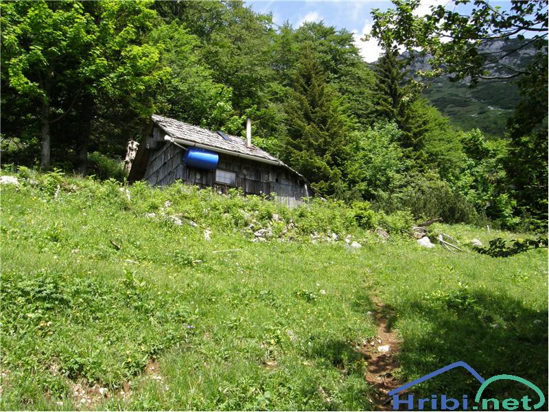
Markova Ravan
