
Mountain Koren
Mountains: Kamnik - Savinja Alps
Latitude/longitude: 46,3069°N / 14,5518°E
Altitude: 1675 m
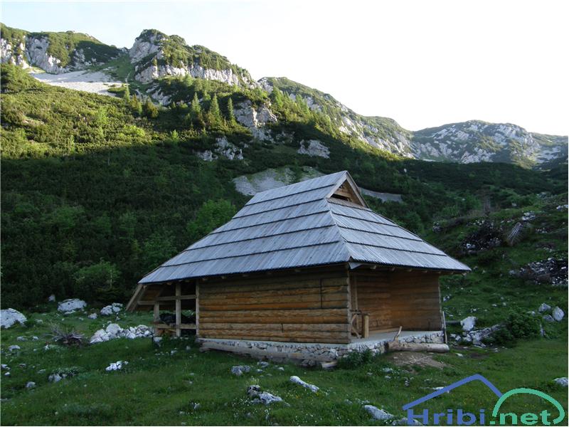
Description: Koren mountain is a still living mountain which is located between Veliki Zvoh and Košutna. The edge of the mountain offers a beautiful view onto a larger animal watering area and in the middle of the mountain, in a smaller valley, there is a pasture cottage that was renewed a few years ago..
Paths:
Kriška mountain - Koren mountain
Mountains: Kamnik - Savinja Alps
Latitude/longitude: 46,2929°N / 14,5369°E
Altitude: 1675 m
Starting point: Kriška mountain (1480 m)
Altitude difference: 195 m
Walking time: 1 h 15 min
Difficulty: easy marked path
Best season for the hike: summer season
Recommended: mountain hiking footwear, hiking poles, crampons and pick in the winter
Access to starting point:
1. From the highway Ljubljana - Jesenice, take the exit Vodice then continue to the first crossroads with a traffic light in Vodice, turning left towards Cerklje na Gorenjskem and Brnik. When you reach the main roundabout in Spodnji Brnik, continue driving towards Cerklje and the Krvavec ski resort. At the end of the town of Cerklje na Gorenjskem, leave the main road which continues towards Velesovo and Visoko and continue slightly to the right towards Krvavec ski resort. Continue to the village Grad, where markings for the settlement Ambrož pod Krvavcem will direct you to the right, onto a steep asphalt road (going straight brings you to the lower station of the cable car Krvavec and Štefanja Gora). When the incline on the steep road evens out a bit, you reach the crossroads, where you continue left towards the settlement Ambrož pod Krvavcem (straight settlements Ravne, Apno and Šentruška Gora). A bit further on, the road transitionally turns into a slight descent, then climbs over slopes that occasionally offer quite a good view. Higher, we reach Ambrož pd Krvavcem, where we drive around the church of St. Ambrož and tourist farm Pr Ambružarju on the left side. From the farm, the road passes into a forest, then climbs all the way to the Jezerca peak, where you will find a large, orderly parking lot.
The road gets flatter here and turns left, then, about 500 m on, it takes us to a crossroads where we turn right towards Kriška Planina (straight on is the top station of the cable car and the mountain lodge on Gospinec). Only a short, steep climb follows and we reach the parking lot at the edge of Kriška Planina.
Recently, the road from the Jezerca peak to Kriška Planina had been closed, which extends the hike for approximately 15 minutes.
2. From the highway Jesenice - Ljubljana take the exit Kranj - vzhod then continue to drive towards Brnik, Komenda and Mengeš. When you reach the main roundabout in Spodnji Brnik, continue driving towards Cerklje and the Krvavec ski resort. At the end of the town of Cerklje na Gorenjskem, leave the main road which continues towards Velesovo and Visoko and continue slightly to the right towards Krvavec ski resort. Continue to the village Grad, where markings for the settlement Ambrož pod Krvavcem will direct you to the right, onto a steep asphalt road (going straight brings you to the lower station of the cable car Krvavec and Štefanja Gora). When the incline on the steep road evens out a bit, you reach the crossroads, where you continue left towards the settlement Ambrož pod Krvavcem (straight settlements Ravne, Apno and Šentruška Gora). A bit further on, the road transitionally turns into a slight descent, then climbs over slopes that occasionally offer quite a good view. Higher, we reach Ambrož pd Krvavcem, where we drive around the church of St. Ambrož and tourist farm Pr Ambružarju on the left side. From the farm, the road passes into a forest, then climbs all the way to the Jezerca peak, where you will find a large, orderly parking lot.
The road gets flatter here and turns left, then, about 500 m on, it takes us to a crossroads where we turn right towards Kriška Planina (straight on is the top station of the cable car and the mountain lodge on Gospinec). Only a short, steep climb follows and we reach the parking lot at the edge of Kriška Planina.
Recently, the road from the Jezerca peak to Kriška Planina had been closed, which extends the hike for approximately 15 minutes.
Path description: From the parking lot we head onto the road in the direction of Koren mountain. The road leads under an overpass and to a quarry, where we leave it. We continue to ascend an otherwise pleasant but poorly visible mountain path, which travels along a pasture fence. The path becomes more visible, then leaves the pasture area of Kriška mountain and moves into a brush overgrown lands. After a shorter ascent, it brings us to a lovely lookout point, from which we have a beautiful view of the Korošica valley. The path proceeds to descend steeply and we are 60m lower after only a few minutes. It then straightens out and from the right, a path from the aforementioned valley joins. We first cross a forest belt, then the path begins to climb once more. During the ascent, an unmarked path which leads to the Razor saddle splits off to the left, while we continue on the marked path which, after a few more minutes, brings us to the southern part of Koren mountain. The path then descends past the animal watering area to the pasture hut on the mountain.
The hike can be extended to the following destinations: Planina Košutna (20 min), Mokrica (1 h 30 min), Košutna (50 min), Kompotela (1 h), Koren peak (1 h), Kalška gora (3 h 5 min), Kalški greben (2 h 30 min)
Markova raven - Koren mountain (along marked path)
Mountains: Kamnik - Savinja Alps
Latitude/longitude: 46,2969°N / 14,5618°E
Altitude: 1675 m
Starting point: Markova raven (980 m)
Altitude difference: 695 m
Walking time: 2 h
Difficulty: easy marked path
Best season for the hike: summer season
Recommended: mountain hiking footwear, hiking poles, crampons and pick in the winter
Access to starting point: We drive to Kamnik and follow the road towards the Kamniška Bistrica valley. Only a few dozen metres before the lower station of the cable car, a forest road splits off to the left and descends into the Korošica valley. The road then crosses a bridge and soon arrives to a crossroad, where we continue straight forward. The road then reaches another crossroad. We have two options from there: 1. we turn left across the bridge and ascend the uphill road. We follow this road to a smaller parking area by Markova Raven. Markova Raven can be recognised by a smaller parking area next to the road, a torrent and a wide dirt road, which leads left and upwards while the road descends steeply. 2. We continue straight and ascend the road to the next crossroad. We then take the left road which becomes very steep and follow it to the parking lot by the left curve from which a broad dirt road splits off. We park at the parking lot by the road.
Path description: From the starting point we continue along a wider dirt track or worse road, which, after a few dozen meters, brings us to the second parking area, from where we continue straight onto a somewhat narrower dirt track, turning left. After a few minutes, the track splits into two parts, we continue along the right, marked one, but only for a few minutes, as the marks take us further right, onto a marked trail towards Krvavec and Koren peaks. The exit isn't marked specially, so we must pay attention to follow the regular markings. The path climbs on the right side of the nearby torrent and has a fairly steep incline. We reach a crossroad where we turn right in the direction of the sign ZA VRATA. The path then transitions into a less thick forest, occasionally crossing a minor meadow, or even a smaller scree. The views, too become more beautiful. The path takes us to the foot of a shorter wall, where, right and upwards, an unmarked path leads to the Koren peak. We continue to the left of the peak, ascending slightly. A short descent brings us to a smaller spring. The path then takes us to the left side of the spring and begins to climb again. The ascent leads through a short stretch of brush, then onto a grassy slope. The path is more difficult to follow, but marked and albeit the markings are rare, they will help us remain on the right trail. After approximately 20 minutes of ascent from the spring, we reach a smaller wooden cottage. Above the cottage, the path turns left and joins a better trodden and marked path, leading from Kriška mountain (Krvavec). We continue to the right and diagonally follow a path without a significant ascent or descent through a forest. Further, the path begins to climb the brush covered slopes with a few trees. After 20 minutes of ascent the slope eases off and we see the pasture cottage at the Koren mountain. The path then passes past the animal watering area to the pasture cottage at the mountain.
The hike can be extended to the following destinations: Planina Košutna, Mokrica, Košutna, Kompotela, Koren peak, Kalška gora, Kalški greben
Markova raven - Koren mountain (unmarked path)
Mountains: Kamnik - Savinja Alps
Latitude/longitude: 46,2969°N / 14,5618°E
Altitude: 1675 m
Starting point: Markova raven (980 m)
Altitude difference: 695 m
Walking time: 1 h 50 min
Difficulty: easy unmarked path
Best season for the hike: summer season
Recommended: mountain hiking footwear, hiking poles, crampons and pick in the winter
Access to starting point: We drive to Kamnik and follow the road towards the Kamniška Bistrica valley. Only a few dozen metres before the lower station of the cable car, a forest road splits off to the left and descends into the Korošica valley. The road then crosses a bridge and soon arrives to a crossroad, where we continue straight forward. The road then reaches another crossroad. We have two options from there: 1. we turn left across the bridge and ascend the uphill road. We follow this road to a smaller parking area by Markova Raven. Markova Raven can be recognised by a smaller parking area next to the road, a torrent and a wide dirt road, which leads left and upwards while the road descends steeply. 2. We continue straight and ascend the road to the next crossroad. We then take the left road which becomes very steep and follow it to the parking lot by the left curve from which a broad dirt road splits off. We park at the parking lot by the road.
Path description: From the starting point we continue along a wider dirt track or worse road, which, after a few dozen meters, brings us to the second parking area, from where we continue straight onto a somewhat narrower dirt track, turning left. After a few minutes, the track splits into two parts, we continue along the right, marked one, but only for a few minutes, as the marks take us further right, onto a marked trail towards Krvavec and Koren peaks. The exit isn't marked specially, so we must pay attention to follow the regular markings. The path climbs on the right side of the nearby torrent and has a fairly steep incline. We reach a crossroad where we turn right in the direction of the sign ZA VRATA. The path then transitions into a less thick forest, occasionally crossing a minor meadow, or even a smaller scree. The views, too become more beautiful. The path takes us to the foot of a shorter wall, where, right and upwards, an unmarked path leads to the Koren peak (straight forward marked path). We take the right part which diagonally ascends across a scree, partly covered in grass. After a few minutes the path turns slightly to the right and crosses an unexceptional and partly overgrown torrent. Immediately afterwards, the trail brings us into a stretch of forest. Here, we come upon a fork into two unmarked paths. We take the left, less visible one, which leads to the Koren peak, while the right (straight) one, which is a bit better, leads to Medvedja cave. Our left path then climbs through the forest and brings us to a smaller valley in a few minutes. A trail that is poorly visible and fairly overgrown in parts guides us along the bottom of the valley by a torrent. The path gets worse and brings us to another crossroad, which we barely notice. We turn left onto a very overgrown path which brings us through brush, a meadow somewhat ahead and onto the Koren peak.
NOTE: Orientation is difficult and I advise against taking this path in foggy conditions.
The hike can be extended to the following destinations: Planina Košutna, Mokrica, Košutna, Kompotela, Koren peak, Kalška gora, Kalški greben
Jezerca mountain - Koren mountain
Mountains: Kamnik - Savinja Alps
Latitude/longitude: 46,2855°N / 14,5314°E
Altitude: 1675 m
Starting point: Planina Jezerca (1410 m)
Altitude difference: 265 m
Walking time: 1 h 30 min
Difficulty: easy marked path
Best season for the hike: summer season
Recommended: mountain hiking footwear, hiking poles, crampons and pick in the winter
Access to starting point:
1. From the highway Ljubljana - Jesenice, take the exit Vodice then continue to the first crossroads with a traffic light in Vodice, turning left towards Cerklje na Gorenjskem and Brnik. When you reach the main roundabout in Spodnji Brnik, continue driving towards Cerklje and the Krvavec ski resort. At the end of the town of Cerklje na Gorenjskem, leave the main road which continues towards Velesovo and Visoko and continue slightly to the right towards Krvavec ski resort. Continue to the village Grad, where markings for the settlement Ambrož pod Krvavcem will direct you to the right, onto a steep asphalt road (going straight brings you to the lower station of the cable car Krvavec and Štefanja Gora). When the incline on the steep road evens out a bit, you reach the crossroads, where you continue left towards the settlement Ambrož pod Krvavcem (straight settlements Ravne, Apno and Šentruška Gora). A bit further on, the road transitionally turns into a slight descent, then climbs over slopes that occasionally offer quite a good view. Higher, we reach Ambrož pd Krvavcem, where we drive around the church of St. Ambrož and tourist farm Pr Ambružarju on the left side. From the farm, the road passes into a forest, then climbs all the way to the Jezerca peak, where you will find a large, orderly parking lot.
2. From the highway Jesenice - Ljubljana take the exit Kranj - vzhod then continue to drive towards Brnik, Komenda and Mengeš. When you reach the main roundabout in Spodnji Brnik, continue driving towards Cerklje and the Krvavec ski resort. At the end of the town of Cerklje na Gorenjskem, leave the main road which continues towards Velesovo and Visoko and continue slightly to the right towards Krvavec ski resort. Continue to the village Grad, where markings for the settlement Ambrož pod Krvavcem will direct you to the right, onto a steep asphalt road (going straight brings you to the lower station of the cable car Krvavec and Štefanja Gora). When the incline on the steep road evens out a bit, you reach the crossroads, where you continue left towards the settlement Ambrož pod Krvavcem (straight settlements Ravne, Apno and Šentruška Gora). A bit further on, the road transitionally turns into a slight descent, then climbs over slopes that occasionally offer quite a good view. Higher, we reach Ambrož pd Krvavcem, where we drive around the church of St. Ambrož and tourist farm Pr Ambružarju on the left side. From the farm, the road passes into a forest, then climbs all the way to the Jezerca peak, where you will find a large, orderly parking lot.
Path description: At the end of the parking lot, where the road turns left and the road towards the nearby Jezerca peak leads right, we notice red mountain direction signs, which direct us straight onto the marked footpath towards Kriška peak, Koren peak, Košutna, Kompotel and Mokrica, which climbs through the pastures of the already mentioned peak. After a shorter ascent, we reach the dirt track and follow it left, where we cross the peak Kržišče (1658 m). The dirt track which we are walking on quickly divides into two parts, we continue on the lower one. Transitionally, we see a lovely view of Kranj, Škofja Loka hills and Storžič, then the path begins to descend slightly. A few minutes of walk follow until we reach the parking lot in the lower part of Kriška mountain.
From the parking lot, we continue towards the Koren peak along a poor gravel road, which passes below an underpass under the skiing track. The marked path turns slightly to the left after the underpass so that we continue to climb parallel to the road next to a line of spruce trees. After a few minutes of mild ascent, we reach the eastern edge of Kriška peak, where a smaller watering area for animals can be seen. We continue slightly to the left, past the pasture fence (right Osredek peak and Kamnik peak), continuing the slight ascent in an approximately same direction. The path continues from the peak onto somewhat steeper slopes of Krvavec, past which we diagonally ascend to the observation point, from which we have a beautiful view of Kržišče (Pokovše), crest of the Kamnik peak, Korošica valley, Velika Planina and nearby Košutna and Veliki Zvoh.
From the observation point, a few steps to the right of the path, we begin to decent more steeply towards the hunting cottage above the Korošica valley. When the descent ends and the path evens out without major altitude changes, we reach a visible but poorly marked crossroad, where the path turns to the right towards the aforementioned hunting cottage and beyond that towards the valley of Korošica and valley of Kamniška Bistrica. On this crossroads, we continue slightly to the left and begin to ascend lightly through a forest. The path quickly passes from the forest to the brush, then past a pasture fence slowly brings us to the next unmarked crossroads, which is in the middle of a sharp right turn.
From the mentioned hairpin turn forward, there is an unmarked trail towards the Razor saddle (saddle between Krvavec and Veliki Zvoh peaks), while we continue along the marked trail. A short diagonal ascent follows and we are brought onto the southern part of the Koren mountain, from where we have a beautiful view of the central part of the mountain and surrounding peaks. From the south part of the mountain, there is a short descent to the nearby pasture hut, which is in the central part of the Koren mountain.
The hike can be extended to the following destinations: Planina Košutna, Mokrica, Košutna, Kompotela, Koren peak, Kalška gora, Kalški greben
