
Kriška Mountain
Mountains: Kamnik - Savinja Alps
Latitude/longitude: 46,2943°N / 14,5359°E
Altitude: 1480 m
Description: Kriška mountain is a broad mountain, which is located between Krvavec (1853 m) and Kržišče (1658 m). In the summertime, it is used for pasture and in the winter, it is full of skiers, as it is a part of the Krvavec ski resort. There is also a pasture hut on it, Pr Florjan, which serves as a kind of pastor or mountain lodge, open all days of the year.
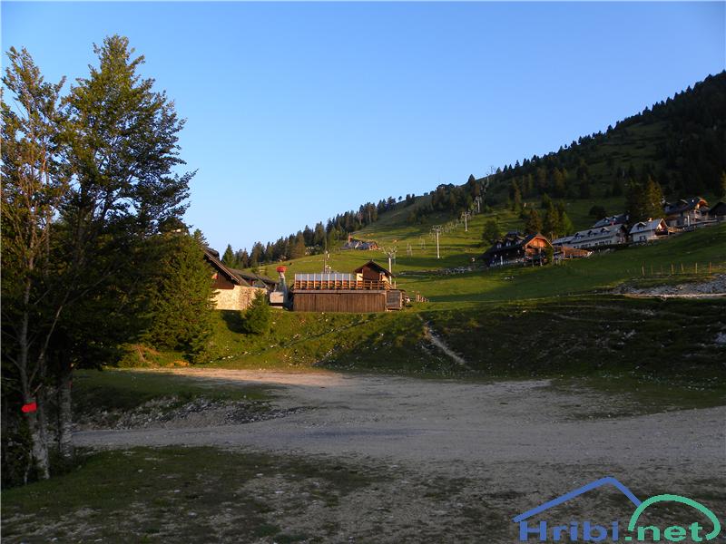
Kriška Planina
Paths:
Jezerca peak – Kriška mountain:
Mountains: Kamnik - Savinja Alps
Latitude/longitude: 46,2855°N / 14,5314°E
Altitude: 1480 m
Starting point: Planina Jezerca (1410 m)
Altitude difference: 70 m
Walking time: 15 min
Difficulty: easy marked path
Best season for the hike: summer season
Recommended: mountain hiking footwear, hiking poles
Access to starting point:
1. From the highway Ljubljana - Jesenice, take the exit Vodice then continue to the first crossroads with a traffic light in Vodice, turning left towards Cerklje na Gorenjskem and Brnik. When you reach the main roundabout in Spodnji Brnik, continue driving towards Cerklje and the Krvavec ski resort. At the end of the town of Cerklje na Gorenjskem, leave the main road which continues towards Velesovo and Visoko and continue slightly to the right towards Krvavec ski resort. Continue to the village Grad, where markings for the settlement Ambrož pod Krvavcem will direct you to the right, onto a steep asphalt road (going straight brings you to the lower station of the cable car Krvavec and Štefanja Gora). When the incline on the steep road evens out a bit, you reach the crossroads, where you continue left towards the settlement Ambrož pod Krvavcem (straight settlements Ravne, Apno and Šentruška Gora). A bit further on, the road transitionally turns into a slight descent, then climbs over slopes that occasionally offer quite a good view. Higher, we reach Ambrož pd Krvavcem, where we drive around the church of St. Ambrož and tourist farm Pr Ambružarju on the left side. From the farm, the road passes into a forest, then climbs all the way to the Jezerca peak, where you will find a large, orderly parking lot.
2. From the highway Jesenice - Ljubljana take the exit Kranj - vzhod then continue to drive towards Brnik, Komenda and Mengeš. When you reach the main roundabout in Spodnji Brnik, continue driving towards Cerklje and the Krvavec ski resort. At the end of the town of Cerklje na Gorenjskem, leave the main road which continues towards Velesovo and Visoko and continue slightly to the right towards Krvavec ski resort. Continue to the village Grad, where markings for the settlement Ambrož pod Krvavcem will direct you to the right, onto a steep asphalt road (going straight brings you to the lower station of the cable car Krvavec and Štefanja Gora). When the incline on the steep road evens out a bit, you reach the crossroads, where you continue left towards the settlement Ambrož pod Krvavcem (straight settlements Ravne, Apno and Šentruška Gora). A bit further on, the road transitionally turns into a slight descent, then climbs over slopes that occasionally offer quite a good view. Higher, we reach Ambrož pd Krvavcem, where we drive around the church of St. Ambrož and tourist farm Pr Ambružarju on the left side. From the farm, the road passes into a forest, then climbs all the way to the Jezerca peak, where you will find a large, orderly parking lot.
Path description:
At the end of the parking lot, where the road turns left and the road towards the nearby Jezerca peak leads right, we notice red mountain direction signs, which direct us straight onto the marked footpath towards Kriška peak, Koren peak, Košutna, Kompotel and Mokrica, which climbs through the pastures of the already mentioned peak. After a shorter ascent, we reach the dirt track and follow it left, where we cross the peak Kržišča (1658 m). The dirt track which we are walking on quickly divides into two parts, we continue on the lower one. Transitionally, we see a lovely view of Kranj, Škofja Loka hills and Storžič, then the path begins to descend slightly. A few minutes of walk follow until we reach the parking lot in the lower part of Kriška mountain peak.
If we wish, we can climb to the nearby pasture hut Pr Florjan.
The hike can be extended to the following destinations: Planina Koren (1 h 15 min), Dom na Krvavcu (35 min), Dolga Njiva mountain (Krvavec) (1 h 35 min), Planina Košutna (1 h 35 min), Mokrica (2 h 45 min), Krvavec (1 h 45 min), Veliki Zvoh (1 h 25 min), Košutna (2 h 5 min), Kompotela (2 h 15 min), Koren peak (2 h 40 min), Kalška gora (4 h 20 min), Kalški greben (3 h 45 min)
