

Dolga Njiva pasture (Krvavec)
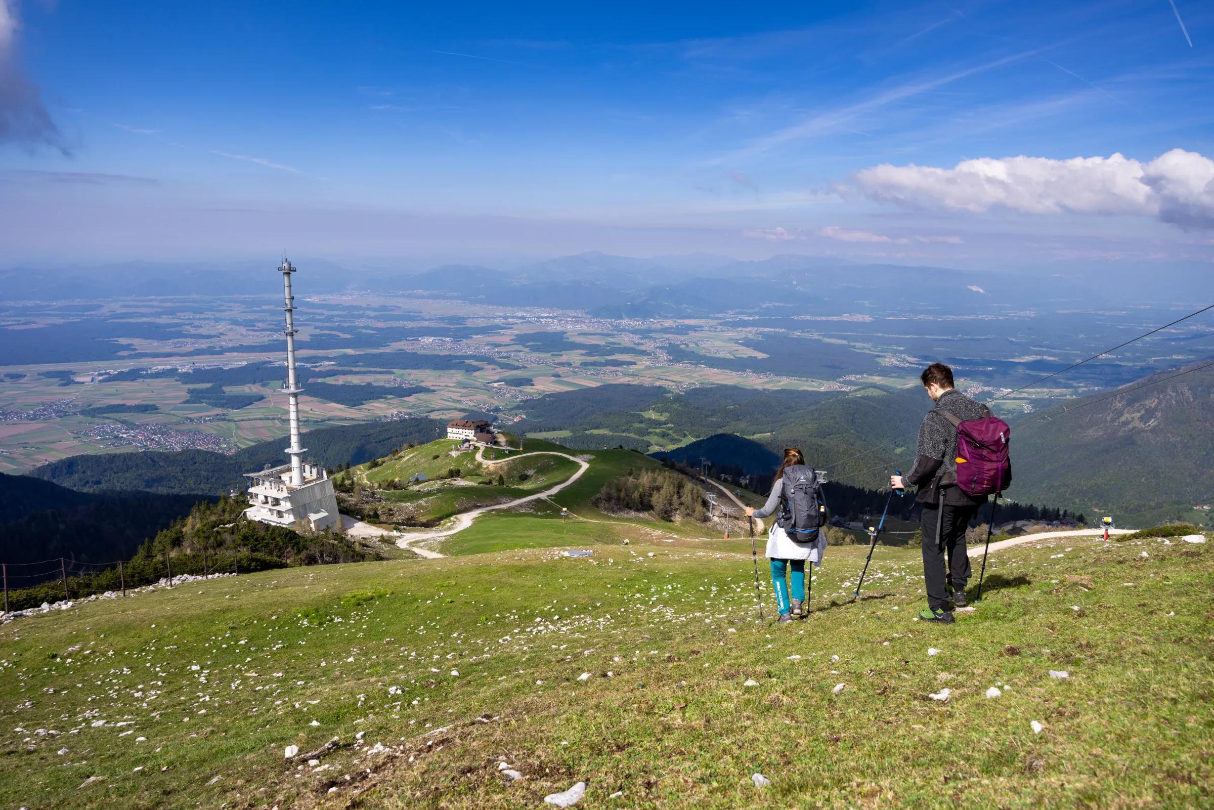
The Dolga Njiva mountain pasture (planina) lies on the extensive grazing grounds below Veliki Zvoh and Vrh Korena.
Hiking
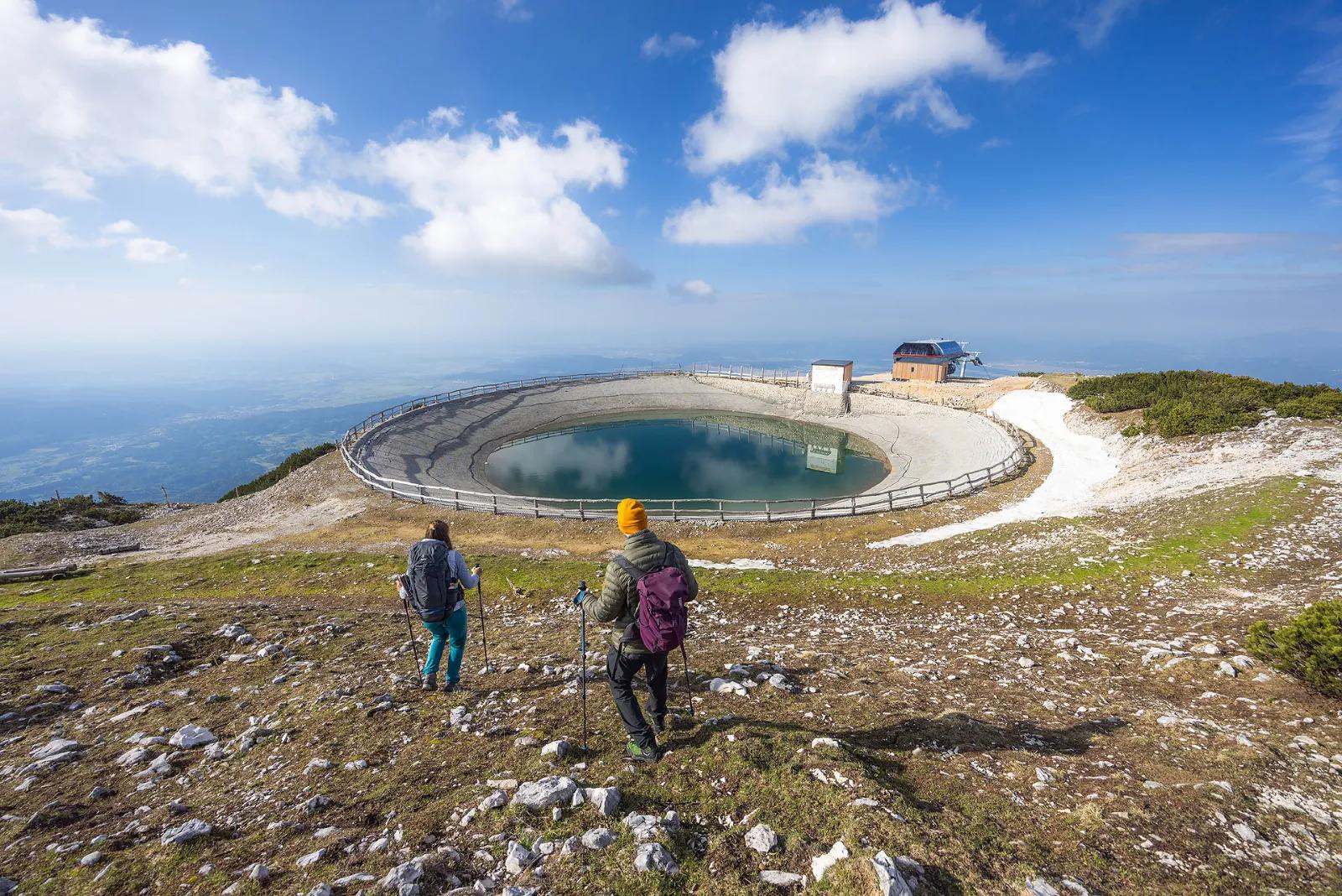
Veliki Zvoh is the highest point of the Krvavec ski resort. The ski lift does not quite reach the summit, but stops only a few metres short of it. A few metres below the summit, a lake has been created for artificial snowmaking on the ski slopes. The summit, which also has a summit register box, offers a fine view towards Kalški Greben and the surrounding peaks. Storžič and part of the Julian Alps can also be clearly seen.
1. From the Ljubljana–Jesenice motorway, take the Vodice exit, then drive on to the first set of traffic lights in Vodice, where you turn left towards Cerklje na Gorenjskem and Brnik.
2. From the Jesenice–Ljubljana motorway, take the Kranj vzhod (Kranj East) exit, then drive on towards Brnik, Komenda and Mengeš.
When you reach the main roundabout in Spodnji Brnik, continue towards Cerklje and the Krvavec ski resort. At the end of Cerklje na Gorenjskem, leave the main road, which continues towards Velesovo and Visoko, and bear slightly right onto the road towards the Krvavec ski resort. You then reach the village of Grad, where signs for the settlement of Ambrož pod Krvavcem direct you right onto a steep asphalt road (straight on for the Krvavec cable car valley station and Štefanja Gora). Once the gradient of the steep road eases slightly, you will come to a junction, where you continue left towards Ambrož pod Krvavcem (straight on for the villages of Ravne, Apno and Šenturška Gora). A little further on, the road briefly descends a little and then climbs across slopes that at times offer fine views. Higher up, you reach Ambrož pod Krvavcem, where you pass to the left of St Ambrose’s Church and the Pr Ambružarju tourist farm. Beyond the tourist farm, the road enters the forest and climbs through it all the way to Jezerca pasture, where there is a large, well-maintained car park.
From the car park, head onto the wide cart track that runs under the lift and begins to climb across the pastures (signposted Dom na Krvavcu). After just under 30 minutes of walking, the moderately steep path brings you to Dom na Krvavcu, from where a lovely view opens up towards Gorenjska (Upper Carniola). From the hut, continue towards Zvoh along the road, which takes you past a chapel and the Krvavec transmitters to the Razor saddle (the saddle between the summit of Krvavec and Veliki Zvoh), where several roads meet. Continue straight on along the ridge (right: Krvavec summit, 5 minutes) and follow the increasingly steep service and rescue road, paved in places, along the edge of the ski piste to the storage reservoir on Veliki Zvoh. From the reservoir, climb to the nearby summit, then cross the wire fence and walk to the summit register box, which is just a few steps below the top.
You can extend the hike to the following destinations: Vrh Korena, Kalška Gora, Kalški Greben
1. From the Ljubljana–Jesenice motorway, take the Vodice exit and continue to the first set of traffic lights in Vodice, where you turn left towards Cerklje na Gorenjskem and Brnik.
2. From the Jesenice–Ljubljana motorway, take the Kranj vzhod (Kranj East) exit, then continue towards Brnik, Komenda and Mengeš.
When you reach the main roundabout in Spodnji Brnik, continue towards Cerklje and the Krvavec ski resort. At the end of Cerklje na Gorenjskem, leave the main road, which continues towards Velesovo and Visoko, and bear slightly right onto the road towards the Krvavec ski resort. Park in the large, well-maintained car park by the Krvavec cable car valley station, where you buy a ticket and take the cable car up to the top station, which is next to the Dom na Gospincu mountain hut.
3. From the Ljubljana–Jesenice motorway, take the Vodice exit and continue to the first set of traffic lights in Vodice, where you turn left towards Cerklje na Gorenjskem and Brnik.
4. From the Jesenice–Ljubljana motorway, take the Kranj vzhod (Kranj East) exit, then continue towards Brnik, Komenda and Mengeš.
When you reach the main roundabout in Spodnji Brnik, continue towards Cerklje and the Krvavec ski resort. At the end of Cerklje na Gorenjskem, leave the main road, which continues towards Velesovo and Visoko, and bear slightly right onto the road towards the Krvavec ski resort. You then reach the village of Grad, where signs for the settlement of Ambrož pod Krvavcem direct you right onto a steep asphalt road (straight on for the Krvavec cable car valley station and Štefanja Gora). Once the gradient of the steep road eases slightly, you will come to a junction, where you continue left towards Ambrož pod Krvavcem (straight on for the villages of Ravne, Apno and Šenturška Gora). A little further on, the road briefly descends a little and then climbs across slopes that at times offer fine views. Higher up, you reach Ambrož pod Krvavcem, where you pass to the left of St Ambrose’s Church and the Pr Ambružarju tourist farm. Beyond the tourist farm, the road enters the forest and climbs through it all the way to Jezerca pasture, where there is a large, well-maintained car park.
At the top station of the Krvavec cable car, you will notice numerous hiking signposts. Head towards Dom na Krvavcu and the Marija Snežna church onto a faint path that climbs almost straight up the grassy slope. Higher up, the faint path leads you over a pasture fence, beyond which it becomes somewhat easier to follow. The fairly steep path then brings you to Dom na Krvavcu, which you can already see from the top cable car station (you can also get here by a rougher gravel road). From the hut, continue towards Zvoh along the road, which takes you past a chapel and the Krvavec transmitters to the Razor saddle (the saddle between the summit of Krvavec and Veliki Zvoh), where several roads meet. Continue straight on along the ridge (right: Krvavec summit, 5 minutes) and follow the increasingly steep service and rescue road, paved in places, along the edge of the ski piste to the storage reservoir on Veliki Zvoh. From the reservoir, climb to the nearby summit, then cross the wire fence and walk to the summit register box, which is just a few steps below the top.
You can extend the hike to the following destinations: Vrh Korena, Kalška Gora, Kalški Greben
1. From the Ljubljana–Jesenice motorway, take the Vodice exit and continue to the first set of traffic lights in Vodice, where you turn left towards Cerklje na Gorenjskem and Brnik.
2. From the Jesenice–Ljubljana motorway, take the Kranj vzhod (Kranj East) exit, then continue towards Brnik, Komenda and Mengeš.
When you reach the main roundabout in Spodnji Brnik, continue towards Cerklje and the Krvavec ski resort. At the end of Cerklje na Gorenjskem, leave the main road, which continues towards Velesovo and Visoko, and bear slightly right onto the road towards the Krvavec ski resort. You then reach the village of Grad, where signs for the settlement of Ambrož pod Krvavcem direct you right onto a steep asphalt road (straight on for the Krvavec cable car valley station and Štefanja Gora). Once the gradient of the steep road eases slightly, you will come to a junction, where you continue left towards Ambrož pod Krvavcem (straight on for the villages of Ravne, Apno and Šenturška Gora). A little further on, the road briefly descends a little and then climbs across slopes that at times offer fine views. Higher up, you reach Ambrož pod Krvavcem, where you pass to the left of St Ambrose’s Church and the Pr Ambružarju tourist farm. Beyond the tourist farm, the road enters the forest and climbs through it all the way to Jezerca pasture, where there is a large, well-maintained car park.
At the end of the car park, where the road bends left and another road branches off right towards the nearby Jezerca pasture, you will see red hiking signposts directing you straight on to the marked footpath towards Kriška Planina, Vrh Korena, Košutna, Kompotela and Mokrica, which climbs across the grazing land of Jezerca. After a short climb, you reach a cart track; follow it to the left as it crosses the slopes of Kržišče (1,658 m). The track soon splits in two; continue straight on along the lower branch. A fine view briefly opens up towards Kranj, the Škofja Loka Hills and Storžič, after which the path begins to descend gently. A few more minutes of walking bring you to the car park at the lower end of Kriška Planina.
Here the marked path to Koren pasture continues slightly to the right, but you continue straight on to the other side of the valley, where you start climbing the grassy slope towards a nearby hamlet. After a short climb, you reach the Pr Florjan dairy hut (planšarija); pass to the right of it. Above the dairy hut, you gradually join a well-trodden but poorly marked path, which begins to climb more steeply up the grassy slope. Higher up, you reach a rougher, partly grassy cart track; follow it uphill to the point where it turns right. From this bend, continue straight on along a somewhat less distinct path, which brings you up to Dom na Krvavcu in a few minutes.
At Dom na Krvavcu, join the gravel road and start climbing along it towards the summit of Krvavec and Zvoh. As you climb, you can enjoy lovely views of the Storžič group, Kočna and Grintovec, and the path gradually takes you past the transmitter tower onto the somewhat steeper slopes of the Krvavec summit. Here the road levels out and traverses the western slopes of the summit, and you soon reach the Razor saddle.
At the saddle, an unmarked path from Koren pasture joins almost unnoticed from the right (it branches off the marked Kriška Planina – Koren pasture path just before Koren pasture), but you continue straight on to the nearby red signposts, which stand a little before the fork where the marked path to Dolga Njiva pasture branches off slightly to the left. Here, too, continue straight on and start climbing steeply along the service and rescue road, which is paved on its steepest section. Higher up, the gradient gradually eases and the path brings you to the storage reservoir used for snowmaking on the ski slopes. Go round the reservoir on the left, then continue slightly right and climb for a few minutes to the panoramic summit of Zvoh.
The stamp and summit register are a little below the summit, beside the marked path that continues towards Vrh Korena.
While the ski resort is operating, walking is prohibited on the section of the route that crosses the ski piste.
You can extend the hike to the following destinations: Vrh Korena, Kalška Gora (3 h 20 min), Kalški Greben (2 h 45 min)
1. From the Ljubljana–Jesenice motorway, take the Vodice exit and continue to the first set of traffic lights in Vodice, where you turn left towards Cerklje na Gorenjskem and Brnik.
2. From the Jesenice–Ljubljana motorway, take the Kranj vzhod (Kranj East) exit, then continue towards Brnik, Komenda and Mengeš.
When you reach the main roundabout in Spodnji Brnik, continue towards Cerklje and the Krvavec ski resort. At the end of Cerklje na Gorenjskem, leave the main road, which continues towards Velesovo and Visoko, and bear slightly right onto the road towards the Krvavec ski resort. You then reach the village of Grad, where signs for the settlement of Ambrož pod Krvavcem direct you right onto a steep asphalt road (straight on for the Krvavec cable car valley station and Štefanja Gora). Once the gradient of the steep road eases slightly, you will come to a junction, where you continue left towards Ambrož pod Krvavcem (straight on for the villages of Ravne, Apno and Šenturška Gora). A little further on, the road briefly descends a little and then climbs across slopes that at times offer fine views. Higher up, you reach Ambrož pod Krvavcem, where you pass to the left of St Ambrose’s Church and the Pr Ambružarju tourist farm. Beyond the tourist farm, the road enters the forest and climbs through it all the way to Jezerca pasture, where there is a large, well-maintained car park.
At the end of the car park, where the road bends left and another road branches off right towards the nearby Jezerca pasture, you will see red hiking signposts directing you straight on to the marked footpath towards Kriška Planina, Vrh Korena, Košutna, Kompotela and Mokrica, which climbs across the grazing land of Jezerca. After a short climb, you reach a cart track; follow it to the left as it crosses the slopes of Kržišče (1,658 m). The track soon splits in two; continue straight on along the lower branch. A fine view briefly opens up towards Kranj, the Škofja Loka Hills and Storžič, after which the path begins to descend gently. A few more minutes of walking bring you to the car park at the lower end of Kriška Planina.
From the car park, continue towards Koren pasture along a rougher gravel road that passes through an underpass beneath the ski piste. After the underpass, the marked path leaves the road slightly to the left and runs parallel to it alongside a sort of avenue of spruces. After a few minutes of gentle ascent, you reach the eastern edge of Kriška Planina, where there is a small watering place for livestock; here, continue slightly left over the pasture fence (right: Osredek pasture and Kamniški Vrh), still climbing gently in roughly the same direction. Beyond the pasture, the path moves onto the somewhat steeper slopes of Krvavec, which you traverse diagonally upwards to a viewpoint with a fine view of Kržišče (Pokovše), the Kamniški Vrh ridge, the Korošica valley, Velika Planina and the nearby Košutna and Veliki Zvoh.
From the viewpoint, which is a few steps to the right of the path, start descending more steeply towards a hunting lodge above the Korošica valley. When the descent ends and the path continues without any major changes in altitude, you will come to a visible but poorly marked junction, where a path branches off right to the hunting lodge mentioned above and on towards the Korošica valley and the Kamniška Bistrica valley. At this junction, continue slightly left and begin climbing gently through the forest. The path soon leaves the forest for shrubs and dwarf pines, then gradually leads you over a pasture fence to the next unmarked junction, which lies right in the middle of a sharp right-hand bend. The marked footpath to Koren pasture continues sharply right, but you continue straight on along a less-trodden yet still easy-to-follow narrow path, which then traverses leftwards across the slopes below Veliki Zvoh. During the traverse, you soon cross a small gully, which poses no difficulty when it is free of snow; however, if there is still snow in the gully, as can happen in late spring or early summer, the crossing is dangerous, as the gully ends in a drop. Further on, the path climbs on a traverse, and besides the fine views you can admire a variety of mountain flowers (Carniolan lily, Turk’s cap lily...). Higher up, the path leads you across a small scree slope and an interesting rocky crag. Pass the crag, which bears a memorial plaque, on its left side, then gradually enter a stretch where the path is somewhat overgrown for a while. When the overgrown section ends, continue slightly right, then follow a less visible narrow path for a few minutes up to the edge of the Krvavec ski slopes.
You reach the ski area at the Razor saddle, where you first need to cross the safety fence; then continue right towards Veliki Zvoh (left for Krvavec and Dom na Krvavcu) to the nearby red signposts, which stand just before the junction where a marked path branches off slightly to the left towards the Dolga Njiva pasture. Here, too, continue straight ahead and begin to climb steeply along the service and rescue road, which is paved on its steepest section. Higher up, the gradient gradually eases and the path brings you to a storage reservoir used for snowmaking on the ski slopes. Walk round the reservoir on its left side, then continue slightly right and within a few minutes climb to the panoramic summit of Zvoh. The stamp and summit register are a little below the summit, beside the marked path that continues towards Vrh Korena.
While the ski area is in operation, walking is prohibited on the part of the route that crosses the ski piste.
You can extend the hike to the following destinations: Vrh Korena, Kalška Gora (2 h 45 min), Kalški Greben (2 h 10 min).
First drive to Kamnik, then continue towards Kamniška Bistrica and the Črnivec pass. At the village of Stahovica, leave the main road to the Črnivec pass and continue left towards Kamniška Bistrica and the Velika Planina cable car. A few dozen metres before the large Kraljev Hrib car park (the car park is near the valley station of the Velika Planina cable car), turn left onto a gravel road, which first descends to the Kamniška Bistrica river and then crosses it by a bridge. On the other side of the bridge you enter the Korošica valley; continue driving along it.
1a. Soon the first road branches off to the right, but continue straight ahead (you can also reach Markova Raven by the road on the right, see description a3) to the next junction, where you turn left (straight on for Markova Raven, see description a2). The road then climbs diagonally to the left for a while, before turning sharply right and leading you across several torrent beds (after heavy rain or a storm the road is difficult or even impossible to drive). Drive on for another few kilometres until, coming off the slope, you reach the Korošica valley, where the road turns sharply right; in the middle of the bend a wide cart track, or rough road, branches off to the left. Park in a suitable spot by the road, or drive a few dozen metres further along the rough road to another small ‘car park’.
1b. Soon the first road branches off to the right, but continue straight ahead (you can also reach Markova Raven by the road on the right, see description a3) to the next junction, where you again continue straight ahead (left for Markova Raven, see description a1). The road climbs moderately alongside the Korošica stream for a while, then becomes very steep and partly rutted (after heavy rain it is often impassable). Higher up, a gravel road joins from the right (see description a3), and after a few hundred metres the road begins to climb steeply again in hairpin bends. When you reach a left-hand bend, in the middle of which a wide cart track, or rough road, branches off to the right, you are at Markova Raven. Park in a suitable spot by the road, or drive a few dozen metres further along the rough road to another small ‘car park’.
1c. You soon reach the first junction, where you continue sharp right (straight on for Markova Raven, see descriptions a1 and a2). After a short drive you reach the slopes above the Kamniška Bistrica river, where you continue left at the nearby junction (the road straight ahead returns to the main road towards Dom v Kamniški Bistrici). The road then climbs alongside a torrential stream for a while, before turning left and crossing the slopes of Mokrica. A little further on, a road branches off to the right and ends in the forest after a few hundred metres, but continue straight ahead to the point where your road joins the one running along the Korošica valley (see description a2). Here continue slightly right; higher up, the road climbs through a few steep hairpin bends. When you reach a left-hand bend, in the middle of which a wide cart track, or rough road, branches off to the right, you are at Markova Raven. Park in a suitable spot by the road, or drive a few dozen metres further along the rough road to another small ‘car park’.
From Gornji Grad via the Črnivec pass, or from Luče via the Volovljek pass, drive towards Kamnik; follow the main road to the end of the village of Stahovica, where you turn right towards Kamniška Bistrica and the Velika Planina cable car. A few dozen metres before the large Kraljev Hrib car park (the car park is near the valley station of the Velika Planina cable car), turn left onto a gravel road, which first descends to the Kamniška Bistrica river and then crosses it by a bridge. On the other side of the bridge you enter the Korošica valley; continue driving along it.
2a. Soon the first road branches off to the right, but continue straight ahead (you can also reach Markova Raven by the road on the right, see description b3) to the next junction, where you turn left (straight on for Markova Raven, see description b2). The road then climbs diagonally to the left for a while, before turning sharply right and leading you across several torrent beds (after heavy rain or a storm the road is difficult or even impossible to drive). Drive on for another few kilometres until, coming off the slope, you reach the Korošica valley, where the road turns sharply right; in the middle of the bend a wide cart track, or rough road, branches off to the left. Park in a suitable spot by the road, or drive a few dozen metres further along the rough road to another small ‘car park’.
2b. Soon the first road branches off to the right, but continue straight ahead (you can also reach Markova Raven by the road on the right, see description b3) to the next junction, where you again continue straight ahead (left for Markova Raven, see description b1). The road climbs moderately alongside the Korošica stream for a while, then becomes very steep and partly rutted (after heavy rain it is often impassable). Higher up, a gravel road joins from the right (see description b3), and after a few hundred metres the road begins to climb steeply again in hairpin bends. When you reach a left-hand bend, in the middle of which a wide cart track, or rough road, branches off to the right, you are at Markova Raven. Park in a suitable spot by the road, or drive a few dozen metres further along the rough road to another small ‘car park’.
2c. You soon reach the first junction, where you continue sharp right (straight on for Markova Raven, see descriptions b1 and b2). After a short drive you reach the slopes above the Kamniška Bistrica river, where you continue left at the nearby junction (the road straight ahead returns to the main road towards Dom v Kamniški Bistrici). The road then climbs alongside a torrential stream for a while, before turning left and crossing the slopes of Mokrica. A little further on, a road branches off to the right and ends in the forest after a few hundred metres, but continue straight ahead to the point where your road joins the one running along the Korošica valley (see description b2). Here continue slightly right; higher up, the road climbs through a few steep hairpin bends. When you reach a left-hand bend, in the middle of which a wide cart track, or rough road, branches off to the right, you are at Markova Raven. Park in a suitable spot by the road, or drive a few dozen metres further along the rough road to another small ‘car park’.
From the starting point, continue along the wide cart track, or rough road, which after a few dozen metres brings you to the second ‘car park’ or turning area. From here continue straight ahead onto a somewhat narrower cart track that bends to the left. After a few minutes the track forks; take the right-hand, marked branch, although you follow it for only a few minutes, as the waymarks then lead you a little further right onto the marked path towards Kamniški Vrh, Krvavec and the Koren pasture (the turn-off is not specially signposted, so follow the waymarks carefully), which begins to climb through the forest. The path then climbs fairly steeply along the right-hand side of a nearby torrent bed; follow it to the next junction, which this time is somewhat better signposted.
At the junction, continue right in the direction of the sign ‘ZA VRATA’ and follow the path through gradually thinning forest, here and there crossing a clearing, a meadow or a short scree slope, from where a fine view opens up, especially of the peaks around the Korošica valley. The path then brings you to the foot of a short rock face, where an unmarked path branches off up to the right towards the Koren pasture, together with a hunters’ traverse path towards Medvedja Jama.
From this junction, take the left-hand path, which skirts the nearby crag on its left side. A little further on there is a gentle descent, and the path brings you to a small, refreshing spring, which unfortunately dries up in dry spells. Next, cross to the left-hand side of the spring and begin to climb again. A climb through a short belt of dwarf pine follows, after which the path comes out onto a grassy slope, where it becomes harder to follow, although the occasional waymarks help. About 20 minutes’ climb from the spring, you reach a small hunting lodge, above which the path turns left and joins a busier, likewise marked path running from Kriška Planina towards the Koren pasture.
When you reach this marked path, continue right, climbing diagonally through the forest. The path soon leaves the forest for scrub and dwarf pine, then, crossing a pasture fence, gradually brings you to the next unmarked junction, which lies right in the middle of a sharp right-hand bend. The marked footpath towards the Koren pasture continues sharp right, but continue straight ahead onto a less trodden but still easy-to-follow narrow path, which then traverses left across the slopes below Veliki Zvoh. Early in the traverse you cross a small gully; when it is free of snow this poses no difficulty, but if there is still snow in the gully, which can happen in late spring or early summer, the crossing is dangerous, as the gully ends in a drop. The path continues to climb diagonally, and besides the fine views you can also admire a variety of mountain flowers (Carniolan lily, Turk’s cap lily, etc.). Higher up, the path leads you over a small scree slope and past an interesting rocky crag. Skirt the crag, which bears a memorial, on its left side, then gradually enter a stretch where the path is temporarily somewhat overgrown. When the overgrown section ends, continue slightly right, then follow a less distinct path to climb within a few minutes to the edge of the Krvavec ski slopes.
You reach the ski area at the Razor saddle, where you first need to cross the safety fence; then continue right towards Veliki Zvoh (left for Krvavec and Dom na Krvavcu) to the nearby red signposts, which stand just before the junction where a marked path branches off slightly to the left towards the Dolga Njiva pasture. Here, too, continue straight ahead and begin to climb steeply along the service and rescue road, which is paved on its steepest section. Higher up, the gradient gradually eases and the path brings you to a storage reservoir used for snowmaking on the ski slopes. Walk round the reservoir on its left side, then continue slightly right and within a few minutes climb to the panoramic summit of Zvoh. The stamp and summit register are a little below the summit, beside the marked path that continues towards Vrh Korena.
While the ski area is in operation, walking is prohibited on the part of the route that crosses the ski piste.
The marked footpath towards the Koren pasture continues sharp right, but continue straight ahead onto a less trodden but still easy-to-follow narrow path, which then traverses left across the slopes below Veliki Zvoh. Early in the traverse you cross a small gully; when it is free of snow this poses no difficulty, but if there is still snow in the gully, which can happen in late spring or early summer, the crossing is dangerous, as the gully ends in a drop. The path continues to climb diagonally, and besides the fine views you can also admire a variety of mountain flowers (Carniolan lily, Turk’s cap lily, etc.). Higher up, the path leads you over a small scree slope and past an interesting rocky crag. Skirt the crag, which bears a memorial, on its left side, then gradually enter a stretch where the path is temporarily somewhat overgrown. When the overgrown section ends, continue slightly right, then follow a less distinct path to climb within a few minutes to the edge of the Krvavec ski slopes.
The stamp and summit register are a little below the summit, beside the marked path that continues towards Vrh Korena.
You can extend the hike to the following destinations: Vrh Korena, Kalška Gora, Kalški Greben
Kriška Planina – Veliki Zvoh – starting point Kriška Planina (1,480 m), walking time 1 h 25 min, ascent 491 m, difficulty: easy marked trail. Dom na Gospincu – Veliki Zvoh – starting point Dom na Gospincu (1,492 m), walking time 1 h 25 min, ascent 479 m, difficulty: easy marked trail. Jezerca pasture – Veliki Zvoh (via Dom na Krvavcu) – starting point Jezerca pasture (1,410 m), walking time 1 h 40 min, ascent 561 m, difficulty: easy marked trail. Jezerca pasture – Veliki Zvoh (by the unmarked path over Razor) – starting point Jezerca pasture (1,410 m), walking time 2 h 15 min, ascent 561 m, difficulty: easy unmarked path. Markova Raven – Veliki Zvoh (by the unmarked path over Razor) – starting point Markova Raven (980 m), walking time 3 h, ascent 991 m, difficulty: easy unmarked trail.
Best time for the hike: summer season.
Source: hribi.net
The Dolga Njiva mountain pasture (planina) lies on the extensive grazing grounds below Veliki Zvoh and Vrh Korena.
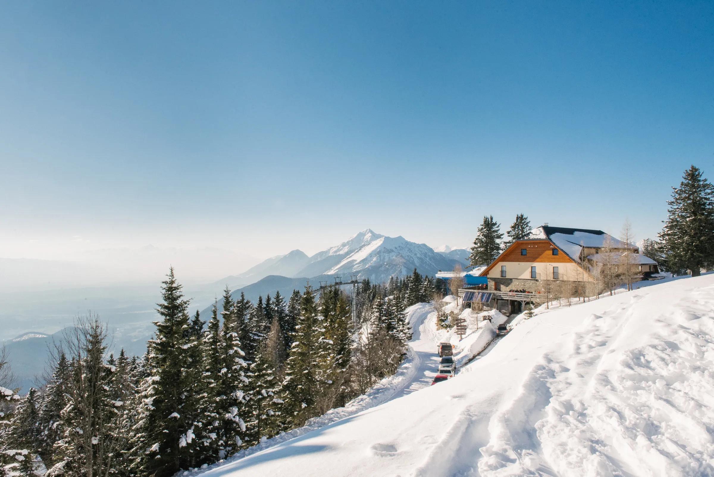
Dom na Gospincu / Hotel Rozka stands right next to the upper station of the Krvavec cable car. The hut offers a fine view of the slopes of the Krvavec ski area and part of the Kamnik–Savinja Alps.
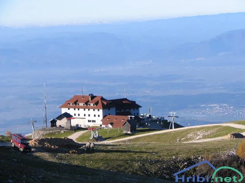
Dom na Krvavcu is a mountain hut just below the summit of Krvavec, close to the transmitter tower. Between the tower and the hut stands Plečnik’s chapel, dedicated to Our Lady of the Snows.